Can Checksite be used to create a course while in the field?

classic Classic list List threaded Threaded
19 messages Options
Reply | Threaded
Open this post in threaded view
|

Can Checksite be used to create a course while in the field?

Guy Lingford
All the courses I have created have been at my laptop. I'll then create a Checksite course and test how accurately the controls created on the kml file relate to 'real life'.

It got me wondering if it was possible to do this in reverse, i.e. walk round the proposed course and at the appropriate location press a button to create the control. While it may take longer to create the course it would simplify the checking of the control location.

Is this possible?
Reply | Threaded
Open this post in threaded view
|

Re: Can Checksite be used to create a course while in the field?

MichaelRaz
Not directly (although could be a useful feature).  You can drop waypoints while on a check site that you can name and they are added to the track GPX file. It would be simple but take a while to pull these out and build a KML. Fairly trivial to code or script this however.  I’m assuming you have a check site setup with only the KMZ.
Reply | Threaded
Open this post in threaded view
|

Re: Can Checksite be used to create a course while in the field?

MichaelRaz
This post was updated on .
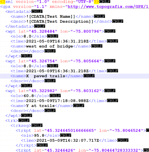
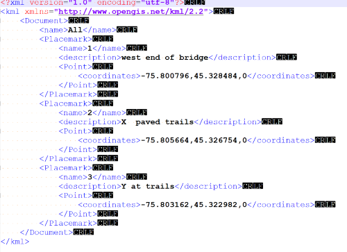
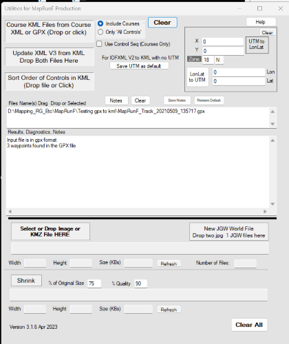
Guy, I spent a couple of rainy day hours updated the utility I use for Maprun stuff and added the ability to drop in a gpx file from a checksite that contains the pins (waypoints),  This will pull out the waypoints and produce a KML.  Given that the pins are likely a bit random in order of dropping, the KML will just keep them in the order from the file numbered sequentially from 1.  If you add a note when you drop the pin (for example: "put on N side of tree", this will be added to the kml under a <description> tag (which is available in the KML format) so will show on Google Earth when you hover over the pin.  Although I've only done some basic testing, this extra tag does not cause a problem with Maprun and is ignored.

Far from perfect but would allow you to adjust and finalize in Google Earth.  No simple way to pull this into Purplepen at the moment as this needs a relationship between a map coordinate system and the geo coordinates of the KML controls.  I have not played with other options yet.  In re3ality this should be an online app - that will need someone else to write.

You are welcome to try this out. The caveat is the app is a windows .exe only so I have not added any specific installation routine and there is the standard risk of running an exe.  The app is available https://drive.google.com/drive/folders/1sMb8t4_nTuQoTo6TUNPt8g2J6dgGKY33?usp=sharing along with some help files and an video.  My QR code generator is at https://drive.google.com/drive/folders/1XRh_A2EgNxSRd_cJ1M0h3SEF83Y0cIW8?usp=share_link with some documentation if you need to generate QR codes.

3 Screen shots: Part of original gpx file from a checksite (with 3 waypoints), the resulting KML, and the app.  Actual KML is attached below:


MapRunF_AllControls.kml
Reply | Threaded
Open this post in threaded view
|

Re: Can Checksite be used to create a course while in the field?

Guy Lingford
Wow - thanks for this. I’m no techie so will need to take baby steps here but thank you so much for taking the time to do this.

No worries about Purple Pen translation - I find that it needs plenty of other manual manipulation for other reasons too.

Regards

Guy
Reply | Threaded
Open this post in threaded view
|

Re: Can Checksite be used to create a course while in the field?

MichaelRaz
No problem - might be a useful tool!  Currently the controls are numbered from 1 sequentially.  I might change it to check the note and if the content before the first space is a number, use that. Example: "31 this is on the N of the boulder" would assign the control code 31

This would need some logic to deal with waypoints without numbers (start at 1 or 1 higher than the current highest and avoid duplicates.
Reply | Threaded
Open this post in threaded view
|

Re: Can Checksite be used to create a course while in the field?

MichaelRaz
Guy,

I actually used this today.  I had a poorly georeferenced map (old but accurate for paper map orienteering).  selected the control locations I thought I would want on the map then went out with a checksite and found the actual locations, dropped waypoints and came home.  Dragged the GPX into the app and had a KML based on the actual locations so I could set up a course with accurate punch locations (people will be using a paper map so the offset of the georeferencing does not matter).

I have updated the app to allow you to predefine some or all of the waypoints control codes as you go. click on the Add Waypoint then start the description with @ followed by the control code you want then a space if you have more text to add - so '@31 N side of boulder' becomes 31 in the KML (the whole description remains in the KML so you can see this in google earth pins but it does not impact the MapRun kml). @s or @f will become S1 or F1.  Any Waypoint without a predefined code will be assigned one starting from 31 (default - can be set for 1).  Note that you can use "incorrect" codes such as 32b but obviously you need to fix this up after.  If you have not visited the controls in the order you want to use for a pt to pt its is easy to
Reply | Threaded
Open this post in threaded view
|

Re: Can Checksite be used to create a course while in the field?

Guy Lingford
Michael - really appreciate your time on this one and do want to take advantage of the efforts spent. A few questions therefore:

App version - I am using v7.1.6 - is this the version you refer to below?
When you say you dragged the GPX into the App - is it into v7.1.6 (or whatever version is relevant) and if so how do you actually do this on the App?
Can any of this be done on MapRun Console?
Do I need to be an administrator or a 'simple' user?

And apologies if any of these have answers that should be obvious...

Thanks
Reply | Threaded
Open this post in threaded view
|

Re: Can Checksite be used to create a course while in the field?

MichaelRaz
It is completely unrelated to the MapRun console or version but a standalone windows application that I wrote primarily to help with my own procedures and processes to get MapRun event files ready for MapRun. I think I added the Google drive link in a previous post. The downside (as this is really something I wrote for myself) it is windows only and I have not wrapped in in any installation package.  Because of this, and because it is a single .exe file, you need to go through numerous Windows warnings “do you really want to download/run this” until you can use the first time.  

The Google folder includes a short instruction on all the functions available including the new one with the GPX file.

I realize that this is not the best way to do this and it really should be a web app - at some point I will need to do some learning and figure out how to code this.

So it really is up to you if you want to use it.  I consider it a proof of concept and think it is a useful tool that you suggested - but does need to be added to a web utility.
Hope that clears things up.

Michael Raz
Reply | Threaded
Open this post in threaded view
|

Re: Can Checksite be used to create a course while in the field?

Guy Lingford
You were right - Windows Defender became extremely agitated and wouldn't, repeatedly, permit me to run the file. Hey ho. Guess I'll need to wait for the version which it is more relaxed about.

Thanks in the meantime for taking this forward and indeed deepening my knowledge of how MapRun works in the background.
Reply | Threaded
Open this post in threaded view
|

Re: Can Checksite be used to create a course while in the field?

MichaelRaz
It will eventually let you - the option is just not made obvious and there will be a few steps the first time. You do need to download it from the google drive in case you are trying to run it from there. It will be something like:
 Select Download from GoogleDrive. A warning about downloading from Google Drive will pop up. Select 'Download Anyway'
Another warning that MapRun Util is not commonly downloaded: click the ... and select Keep Anyway
You can then move the .exe someplace in your folders.
First time you double click (run) it a grey security box will pop up with an end of the world warning.  Click the More Information bit and then Run Anyway.

After that it will be fine.

I'll need to build a better deployment wrapper around it!
 
Reply | Threaded
Open this post in threaded view
|

Re: Can Checksite be used to create a course while in the field?

Guy Lingford
Still not having it sadly! I do see the warning messages and then one to say that the downloaded file has been deleted. Guess your permissions are at a higher setting than mine to reflect our respective technical nous.
Reply | Threaded
Open this post in threaded view
|

Re: Can Checksite be used to create a course while in the field?

MichaelRaz
Too bad. As a last resort I took a copy of the .exe, changed the extension to .notexe then zipped it.  Look for MapRunFUtils.zip, try to download and, if successful, unzip it and change the extension back to .exe. Not sure if this will work but I've also attached it here

In the mean time I decided it was about time I learned to do some web coding (PHP) so starting to take a look at this - it should be a fairly easy right but it will take some playing around!

I'm also happy to do the conversion for you at any time if you send me a GPX file.  Assuming I'm home it takes just seconds.
MapRunFUtils.zip

Edit, I can also try emailing it if you send me your email (through the Send Email function to me assummin you want to keep it private)
Reply | Threaded
Open this post in threaded view
|

Re: Can Checksite be used to create a course while in the field?

Guy Lingford
Hi Michael - thanks again for looking at this so quickly and sending an alternative file. Outcome sadly is the same and my attempt to provide a screenshot of the message is simply gobbledygook when pasted into this message box.......

I aim to revisit the site over the next few days so will be pleased to take you up on the offer of forwarding the GPX file.

Regards

Reply | Threaded
Open this post in threaded view
|

Re: Can Checksite be used to create a course while in the field?

MichaelRaz
Okay.  here is the extract from the instructions related to this specific function. This describes how each waypoint is assigned a name in the KML (the control code).  You can assign one or more waypoints a specific code as you enter the waypoint into the checksite.  Remainder will be assigned by the app. Obviously this may need adjusting in Google Earth after.  I realize that what is missing below is if you use @f or @s these will be changed to F1 and S1.


V3.1.7 Added GPX to KML function. Using MapRun Checksite you can save a route including
drop pins (waypoints in the GPX file). Drop the GPX file here and a KML will be produced from
the waypoints in the GPX. To pre-assign control codes to the waypoints, start the description
with an’@’ followed by the desired code (and space if you want to add more text in the
description). Example: ‘@32 N side of boulder’ will result in a the KML control name for that
waypoint as 32. Original text is maintained within a Description element in the KML so it is
visible in Google Earth but does not impact the KML for MapRun. Control codes are
automatically assigned to waypoints without a leading ‘@’ starting from 31 up. Select the “Use
Control Seq” button will start numbering from 1. Note that pre-assigned codes are not
checked so you can use things like ‘@31b’ if needed but this must be changed to actually work
in MapRun.
Reply | Threaded
Open this post in threaded view
|

Re: Can Checksite be used to create a course while in the field?

Guy Lingford
Hello Michael I have a GPX with Waymarks following my walk around part of the course today and asking if you can apply your coding and convert to KML? Do you need the underlying KMZ file? How do I actually send you the GPX? Many thanks (again!)
Reply | Threaded
Open this post in threaded view
|

Re: Can Checksite be used to create a course while in the field?

MichaelRaz
This post was updated on .
Just email as attachment to razmichael at yahoo.ca or I think you can attach to the forum post.
Only need the GPX (KML is not directly related to the KMZ other than the coordinates in the KML should be in the area covered by the KMZ mao).

I'm finishing up a on-line version - just putting in the file upload capability - never coded in PHP before so taking some time!

Edit:  see http://maprun.308.s1.nabble.com/KML-from-Checksite-GPX-Web-Tool-td1663.html for link and detail for online version
Reply | Threaded
Open this post in threaded view
|

Re: Can Checksite be used to create a course while in the field?

d-dixon
I'm coming a bit late to this thread but I can add an alternative way of getting gpx waypoints into a kml.

Try using oomap: https://oomap.dna-software.co.uk/

The instructions here provide the detail: https://oomap.dna-software.co.uk/help/details/importing-controls/

...but in short, drag & drop a gpx file onto the map - this will import the track and any waypoints into a temporary layer.  Double-click on the waypoints to promote to controls.  You can then export the control list to a MapRun-compatible KML file.  You can, but don't need to, export a street map base if you wish too.

David
Reply | Threaded
Open this post in threaded view
|

Re: Can Checksite be used to create a course while in the field?

Guy Lingford
Hi and thanks for your message. It is in fact very timely as I am starting work on a new course near the Roaches in Staffordshire UK.

I'll look to see how I can use oomap.

Regards

Guy
Reply | Threaded
Open this post in threaded view
|

Re: Can Checksite be used to create a course while in the field?

MichaelRaz
Nice to have multiple options.  This did prod me to note that (in this thread) I don't think I posted the link to my set of online tools that include the capability to produce a KML from a Checksite GPX with waypoints.  Depending on the goal, this tool has the advantage that it will number the controls as per a MapRun KML either automatically or by reading numbers included in the waypoint description.  On the same page is another tool that will further clean up a KML (fix start finish etc).  Anyway - different solutions for different use cases are always good!

https://maprun.raz-family.ca/