Longitude error on Checksites
|
HI,
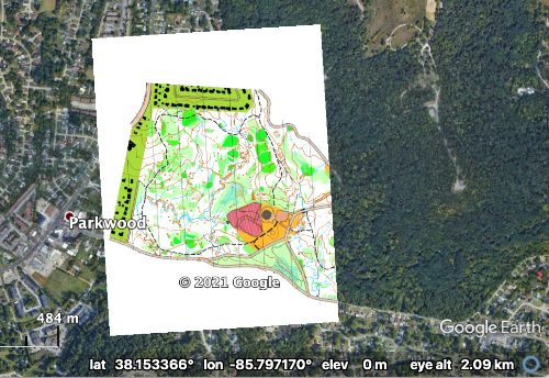
I am new to MapRun and despite a few efforts, I keep receiving an error message: "Invalid argument(s): Longitude must be between -90 and 90 degrees but was 274.2003044287447." I created both files (KMZ, KML) with no problems and am using OOMapper for the Georeferenced Map and Purple Pen for existing course. These line up perfectly on Google Earth. I am assuming this has something to do with my phone settings (Iphone 12 pro) but not sure. I receive the 6 digit code and but when going to the Go to Start button on the app, this is when the error appears. I am sure since I am new at this, it is something that I did not see in the instructions. The map is in KY, USA Thanks for all your work on this Bruce |
|
Not sure if I can help but if you can post your KML (and KMZ if possible) happy to take a look at the contents. Forgive if you already know this but the KML is just a text file (in a Markup Language like XML) and the KMZ is a compressed combination of a jpeg map (or maps if tiled) and a KML file that describes the georeferencing of the jpeg file(s). These can be viewed and modified using a basic compression software like the free 7Zip. Reviewing these might show what is causing Maprun to have issues and then, working backwards, figure out why. I highly doubt that it has anything to do with your phone.
|
|
Thanks Michael,
I have looked at the KML and it looks correct to me.
I am not sure how to attach files here so I am guessing this is displayed.
Summer2021GoGo5a.kml
|
|
Problem is the KMZ. The E and W boundaries are causing the issue. How did you produce it? Here is an extract of the included file doc.kml in the KMZ:
<?xml version="1.0" encoding="UTF-8"?> <kml xmlns="http://earth.google.com/kml/2.2"> <Folder> <name></name> <GroundOverlay> <name>tile_0_0.jpg</name> <drawOrder>75</drawOrder> <Icon> <href>files/tile_0_0.jpg</href> <viewBoundScale>0.75</viewBoundScale> </Icon> <LatLonBox> <north>38.1523498945329</north> <south>38.151573672630356</south> <east>274.20129157258765</east> <west>274.2003044187447</west> <rotation>3.530193978043776</rotation> </LatLonBox> </GroundOverlay> <GroundOverlay> <name>tile_1_0.jpg</name> <drawOrder>75</drawOrder> <Icon> <href>files/tile_1_0.jpg</href> <viewBoundScale>0.75</viewBoundScale> </Icon> <LatLonBox> <north>38.15239769003357</north> <south>38.151621468131026</south> <east>274.2022768532946</east> <west>274.20128969945165</west> <rotation>3.530193978043776</rotation> </LatLonBox> |
|
I thought that maybe this was caused by me trimming the map but this is way off.
The map was produced using Lidar and OpenStreetMap. Everything has lined with GPS and there have not been any problems so I have no idea. I am going to take a look at other maps here and see if I can find the same issue |
|
Edited: It is not really way off as it is a 360 degree error (looks like the numbers are correct - just take away 360 ). I also noted that the rotation in the KMZ is around 3 degrees - I would have expected more like 5.3 if this is simply Magnetic North.
|
|
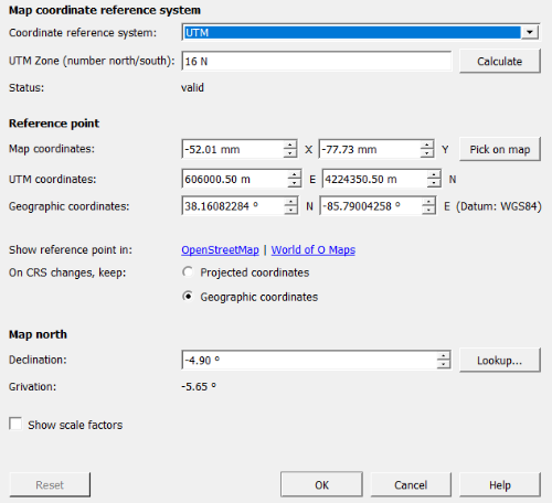
I think the rotation is off a bit and it should be 4.9 degrees.
The Geographic coordinates are as follows. The -85.xxx represents the 274.xxx. 
|
Re: Longitude error on Checksites
|
Administrator
|
Bruce,
Adding to Michael's comments... Real-world Longitude ranges from -180 to 180 degrees. I'd need to search into the code (and the software modules used) as the error message is in error if it says "Longitude must be between -90 and 90 degrees". If you see in Google Earth, the longitude that the map is places at is Longitude -85.8. Which is correct. So Google is doing the maths to bring 274 back into the -180 to 180 range.  MapRun doesn't do that ... it just wants the Longitude to be in the real-world range: -180 to 180. You could manually edit the KMZ file ... but I'm pretty sure the issue can be solved in the tools you are using to create the KMZ. Peter |
|
Thanks Peter, I did notice the 90 factor and thought that was odd when talking about 360 degrees. I should be able to do a search and replace for the longitude in the text file and see how that works. I am curious about why this is happening. I do not think it is isolated to one map. I checked another map in the area and the same thing happened.
|
|
Are you using OpenOrienteering Mapper (OOM, the application) to generate the KMZ? I have never seen this in OOM. I just tried to reproduce it using a Template jpeg and world file from OpenorienteeringMap (the online service) in the same area. I was wondering it was a bug in OOM based on the UTM or general area but it worked fine (the KMZ is good). As you noted, you can just open up the KMZ and edit the doc.kml to replace all >274 with >-85 but this does not explain the root cause.
As a side note. I have found with OOM that if you add some objects, save in omap format and open in Purple Pen, it may cause some shifts in the objects location in the PP file. The work around is to save the OOM map in the OCAD format and use this with PP. |
|
Michael,
Thanks for posting that! I suddenly realized when you asked me if I created a KMZ File directly from OOM that I might not have the latest version. I had 9.4 and so I downloaded the new version and it worked. I would not have even thought that there was a problem with the version I had. Possibly a bug in OOM? I had not heard anyone else posting a problem with earlier versions. Bruce |
|
Good news. The KMZ feature in OOM is fairly new and there were a few bugs in the first versions. I wish they also offered the option to produce the KMZ untiledas it is very difficult to adjust anything once tiled.
|
«
Return to MapRun
|
1 view|%1 views
| Free forum by Nabble | Edit this page |

